National advancement requires robust infrastructure. The Karakoram Highway Blocked due to recent heavy rainfall and snowfall across Gilgit-Baltistan and Khyber Pakhtunkhwa has disrupted a vital artery, causing thousands of travelers to be stranded. This critical transportation bottleneck, spanning from Diamer to Kohistan, necessitates a precise operational response to restore fundamental connectivity across Pakistan’s northern regions. This scenario, where the Karakoram Highway Blocked key transit routes, demands immediate and calibrated action.
The Translation: Deconstructing Northern Pakistan’s Connectivity Challenge
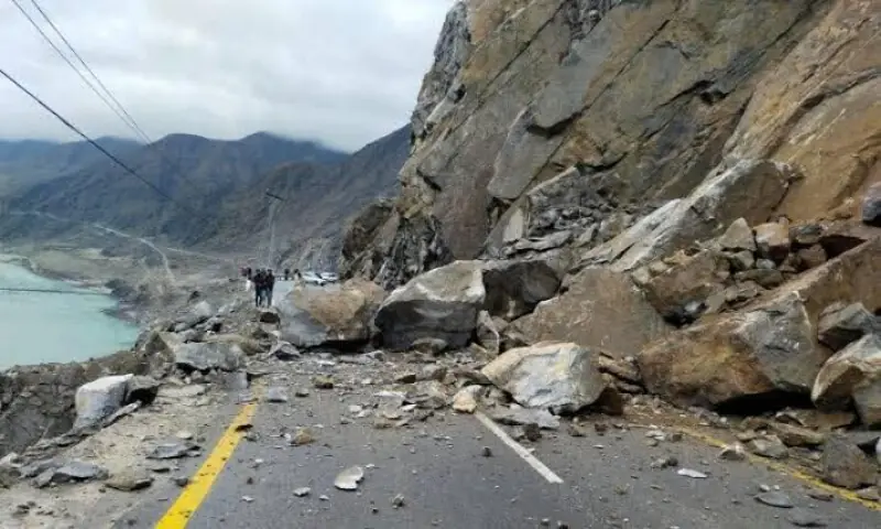
Unprecedented weather conditions, specifically fresh rain and snowfall, have instigated significant geological instability. Landslides, particularly in the Diamer and Kohistan districts, have structurally compromised the Karakoram Highway. Authorities, including Diamer police and Deputy Commissioner Attaur Rehman Kakar, confirm multiple blockages from Barseen in Upper Kohistan to Pattan in Lower Kohistan. Consequently, all travel between Gilgit-Baltistan and other national sectors is temporarily suspended, awaiting optimal conditions for clearance operations by the Frontier Works Organisation (FWO).

Intermittent precipitation across most of Gilgit-Baltistan over the past two days, with higher elevations receiving fresh snowfall, has further complicated the situation. This climatic variability directly triggered additional landslides in remote areas, consequently severing road links and significantly limiting inter-community access. The challenge extends beyond mere debris removal to include safeguarding isolated populations.

The Socio-Economic Impact: Disruptions to Daily Life and Regional Dynamics
The immediate and tangible impact of the Karakoram Highway Blocked extends beyond mere travel delays. Thousands of citizens, including patients requiring medical transit, elderly individuals, and children, are directly affected, facing critical disruptions to their journeys. For students and professionals in Gilgit-Baltistan, this event signifies a direct impediment to educational and economic opportunities, disconnecting them from national centers. Furthermore, these road closures sever essential supply chains for urban and rural households, potentially leading to resource scarcity and calibrated price increases in isolated communities. This highlights the vulnerability of regional economies to infrastructural interruptions.

The prolonged closure also impacts tourism, a nascent but vital sector for Gilgit-Baltistan’s economic diversification. Operators face cancellations, and local businesses dependent on traveler traffic experience calibrated revenue reductions. Understanding these multi-faceted socio-economic ripples is crucial for comprehensive disaster response and strategic future planning.
The Forward Path: A Stabilization Move for Critical Infrastructure
This incident represents a critical “Stabilization Move” rather than a “Momentum Shift.” While a temporary setback, it underscores the necessity for resilient infrastructure planning in volatile geological zones. The proactive engagement of the FWO for debris removal is a positive indicator. However, a structural re-evaluation of high-risk highway segments and the implementation of advanced early warning systems for landslides are strategically imperative. This approach would calibrate Pakistan’s northern connectivity against future climatic variabilities, ensuring sustained progress and minimizing operational disruptions.

Moving forward, the strategic integration of geospatial data and predictive analytics can significantly enhance the operational efficiency of maintenance efforts. Moreover, investing in robust, weather-resistant construction methodologies for new and existing infrastructure segments will fortify Pakistan’s critical transportation arteries against recurrent natural hazards, ensuring long-term national advancement.